
The World Map Is Being Rethought: Why India Backed the UN’s ‘Correct the Map’ Resolution
For generations, millions of schoolchildren have looked at the same familiar world map and assumed that what they saw was an accurate picture of the planet.
It was not.
On September 4, 2026, the United Nations General Assembly took an unusual but significant step towards correcting that perception. It adopted a resolution titled “Correct the Map: Rebalancing Global Cartographic Representation and Promoting Equitable Representation of the World’s Regions, Particularly Africa.”
The resolution received 164 votes in favour, one against and six abstentions. India voted in favour. The United States was the only country to vote against, while Estonia, Georgia, Lithuania, Moldova, Serbia and Ukraine abstained.
But this is not quite the story of the United Nations simply replacing one world map with another.
The more interesting story is about how maps shape our understanding of the world — and why India believes geographical representation should be more accurate.
Why is the Mercator map controversial?
The familiar Mercator projection was developed by Gerardus Mercator in 1569. Its great strength was navigation: it preserves angles and directions in a way that made it extremely useful for maritime travel.
Its weakness is size.
As landmasses move farther north or south from the Equator, their apparent size becomes increasingly exaggerated. Consequently, countries and regions in the tropics can appear much smaller than their actual areas. Africa is particularly striking.
On a Mercator map, Greenland can appear comparable in size to Africa.
In reality, Africa is roughly 14 times larger than Greenland.
This does not mean the Mercator projection was “wrong” for the purpose for which it was designed. It means that a map created for navigation is not necessarily the best map for teaching people about the relative size of continents.
That distinction is important.
What did the UN actually decide?
The UN resolution does not ban the Mercator projection.
Nor does it legally force every country, school, publisher or technology company to immediately replace its existing maps.
Instead, the resolution promotes more accurate cartographic representation and encourages consideration of equal-area projections, which preserve the proportional areas of landmasses more faithfully. UN General Assembly resolutions of this nature are not equivalent to binding international legislation.
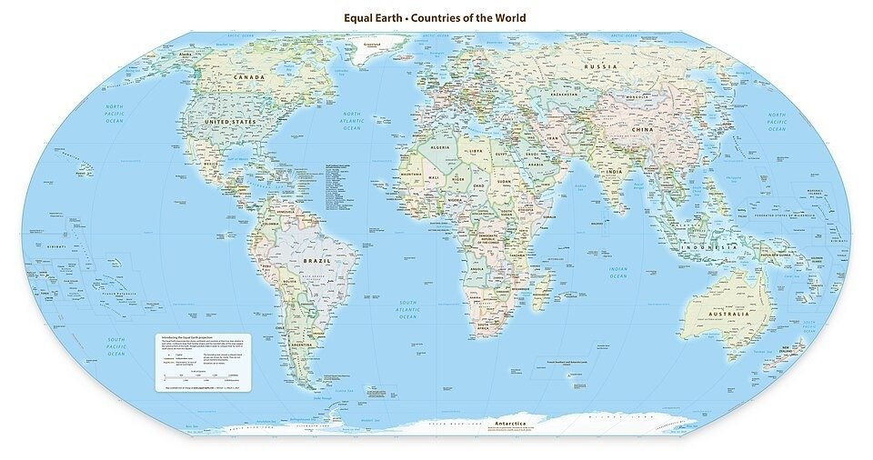
One projection receiving considerable attention is Equal Earth, developed in 2018 specifically to provide a visually balanced world map while preserving relative area.
However, there is an important Indian nuance that should not be lost amid headlines suggesting that the UN has simply “adopted the Equal Earth map.”
India has clarified that its support is for equal-area projections generally, rather than an endorsement of one particular projection.
That is a significant distinction.
Why does this matter to India?
India’s interest is not merely academic.
India is one of the world’s largest countries by area and population, yet the way the world is visually presented can influence how people intuitively understand geography.
The broader issue is particularly relevant to the Global South.
Africa, South Asia and Latin America are among the regions whose apparent size can be substantially distorted on conventional Mercator maps. The UN resolution specifically refers to the need to address such distortions and promote a more equitable representation of world regions.
India’s vote therefore fits naturally with its longstanding interest in greater representation for developing countries in international institutions.
But it would be an exaggeration to claim that the resolution suddenly changes India’s geographical importance.
India’s actual size has not changed. The map has.
A map can influence perception — but accuracy must come first
There is an important lesson here for readers.
Maps are not photographs of the Earth. They are mathematical representations of a three-dimensional planet on a two-dimensional surface.
And every projection involves compromises.
Some projections preserve area. Others preserve direction, distance or shape. No flat world map can reproduce every property of the globe perfectly. Equal Earth improves the representation of relative area, but it is not magically distortion-free in every respect.
That is why the debate should not become a simplistic argument that one map is “true” and every other map is “false.”
The better question is:
What is the map being used for?
A navigator may need one projection. A geography textbook may benefit from another. A climate map may require yet another.
The DOONITED perspective
The most valuable part of the UN decision may therefore be bigger than the map itself.
It reminds us that representation matters.
For decades, students have learned geography from maps without necessarily being told why countries and continents appear the way they do. Introducing more accurate equal-area representations can give students a better understanding of the physical scale of the planet.
For India, the issue also carries a wider Global South dimension. Supporting a more proportionate representation of Africa, South Asia and other regions is consistent with the principle that global understanding should be based on geographical reality rather than visual familiarity.
But the change should be approached scientifically, not ideologically.
The Mercator projection was an important technological achievement for navigation. Its limitations do not erase its historical value. Likewise, a newer projection should be judged by what it improves and what it sacrifices.
The real achievement would be to teach people why maps differ.
Because the world itself has not changed.
What is changing is the way we choose to see it.

World Beyond the News
Why Elephants Stay Close to Their Herd
Elephants live in highly social family groups and use calls, touch and body movements to maintain strong bonds.
Most of the Deep Ocean Remains Difficult to Explore
Extreme pressure, darkness and distance make deep-ocean exploration one of Earth’s greatest scientific challenges.
Spacecraft Can Travel Without Traditional Roads
Spacecraft use carefully calculated trajectories and gravity assists to travel enormous distances through space.
Why Movie Trailers Are Released in Stages
Major films often use teaser trailers, full trailers and final promotional spots to build awareness over time.