
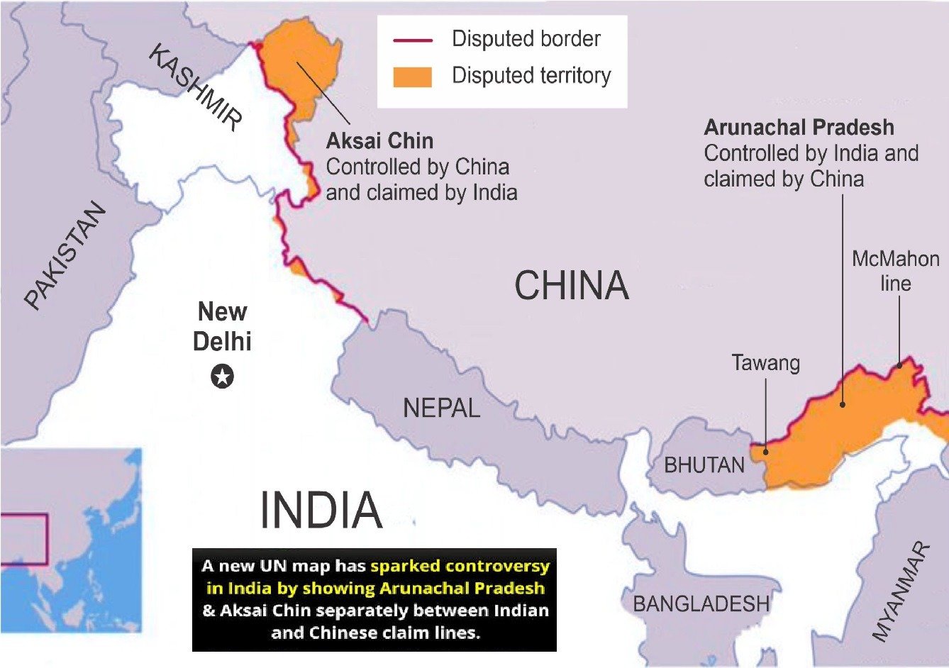
Depiction of Arunachal Pradesh and Aksai Chin
A map normally sits quietly on a wall, in a textbook or inside a geography application.
But sometimes a map becomes foreign policy.
That is exactly what has happened after India raised concerns over the way Arunachal Pradesh and Aksai Chin appear on a recently published United Nations world map.
The controversy is particularly interesting because it comes only days after India supported a United Nations General Assembly resolution promoting greater use of equal-area world maps.
At first glance, that may look contradictory.
India supports a new approach to mapping the world—and then objects to a UN map.
But the two issues are not actually the same.
And that distinction is at the heart of the story.
What does the UN map show?
The United Nations Geospatial section published its latest Map of the World on July 1, 2026. The UN’s own page identifies UN Geospatial as the author and lists the publication date.
The map uses the Equal Earth projection, a system designed to represent the relative areas of continents and countries more accurately than projections such as Mercator.
However, the treatment of disputed India-China territory has attracted attention in India.
According to reporting on the map, Arunachal Pradesh appears between Indian and Chinese lines, while Aksai Chin is similarly represented as a separate area between competing lines. The depiction also omits the familiar internal boundary between Arunachal Pradesh and Nagaland and presents the territory in a way New Delhi considers misleading.
India’s position is unequivocal.
New Delhi considers Arunachal Pradesh an integral part of India and regards Aksai Chin as part of Ladakh, even though Aksai Chin is under Chinese control.
The Ministry of External Affairs has therefore taken up what it described as “anomalies” with the concerned persons.
But didn’t India just support the UN map initiative?
This is where the story becomes more complicated—and more interesting.
On September 4, 2026, the UN General Assembly adopted the African Union-backed “Correct the Map” resolution.
The initiative seeks wider use of equal-area projections because conventional world maps can dramatically distort the apparent size of countries and continents.
The resolution was approved by an overwhelming majority, with 164 countries voting in favour, six abstaining and the United States voting against.
India voted in favour.
But India did not vote to approve a particular political map.
That distinction was subsequently emphasised by MEA spokesperson Randhir Jaiswal.
India’s support was based on the principle of improving the proportional representation of land masses. The resolution, according to India’s interpretation, does not authenticate a particular world map or settle political boundaries and disputed territories.
In simple language:
India supported the mathematics of the map, not a change in its territorial position.
That is a rather important difference.
Equal-area maps versus political boundaries
There are really two separate questions here.
Question one: How large should Africa, India, Greenland or other parts of the world appear on a world map?
That is a cartographic question.
Question two: Where exactly should an international boundary or disputed territory be shown?
That is a political and geopolitical question.
The “Correct the Map” initiative primarily addresses the first.
India’s objection concerns the second.
The Equal Earth projection was introduced in 2018 to reduce the area distortion found in many conventional projections. The Mercator projection, for example, is extremely useful for navigation because it preserves directions, but it makes areas toward the poles appear much larger relative to areas near the equator.
Greenland is the classic example.
On some world maps it looks almost comparable to Africa.
In reality, Africa is enormously larger.
Maps, therefore, can distort geography without anyone deliberately trying to distort politics.
But once boundary lines enter the picture, the stakes change.
Why Arunachal Pradesh matters
Arunachal Pradesh is not simply another state on India’s northeastern map.
It is at the centre of a long-running India-China boundary dispute.
China claims large parts of the state and refers to it as “Zangnan”. India rejects that claim and maintains that Arunachal Pradesh is an integral part of the country.
The region has consequently become a recurring point of diplomatic friction.
For India, the concern over an international map is therefore not about cartographic aesthetics.
Maps produced by major international organisations can influence how students, researchers, institutions and the wider public understand geography.
That is why seemingly small lines on a map can become diplomatically significant.
And what about Aksai Chin?
Aksai Chin presents a different geographic reality.
India regards the region as part of Ladakh, while China controls it.
The Line of Actual Control and the broader India-China boundary dispute have remained unresolved.
Consequently, international maps often use special conventions to communicate disputed boundaries.
The UN’s own mapping conventions acknowledge the complexity of disputed areas. Its new map, for example, uses a dotted representation for the Line of Control in Jammu and Kashmir and includes a note explaining that the final status remains unresolved between India and Pakistan.
This is precisely why the wording and symbols used on international maps matter.
A line can communicate uncertainty.
Another line can communicate an administrative boundary.
And a missing line can create an entirely different impression.
Cartography may look like geography.
Sometimes it is diplomacy in very small print.
Has the UN changed India’s borders?
No.
This is perhaps the most important point for readers.
A UN world map does not legally redraw India’s international borders.
Nor does the September 4 resolution settle the India-China boundary dispute.
The UN General Assembly resolution itself is not a legal settlement of territorial disputes. Its principal purpose is to encourage the use of equal-area cartographic representations.
Therefore, headlines suggesting that the UN has somehow “given” Arunachal Pradesh or Aksai Chin to China would go far beyond the facts.
The controversy is about representation, not a legal transfer of territory.
That distinction should remain firmly in any responsible reporting.
Why India’s reaction matters
India’s response reflects a long-standing diplomatic principle: international organisations should not publish representations that New Delhi considers inconsistent with its official territorial position.
At the same time, India has demonstrated that it is willing to support multilateral initiatives when it agrees with their underlying principle.
There is no inherent contradiction in doing both.
A country can say:
“We support a fairer way of representing the size of continents.”
And simultaneously say:
“We do not accept a particular depiction of our territory.”
In fact, that is exactly what India has done.
The bigger lesson: maps are never completely innocent
Modern digital life has made maps almost invisible.
We open an application, search for a city and follow the blue line.
But political maps carry another layer of meaning.
They can influence schoolbooks, news reports, international presentations and public understanding.
That does not mean every cartographic difference is deliberate propaganda. Sometimes maps contain technical errors, outdated data, different conventions or unresolved disputes.
The responsible response is therefore neither instant outrage nor instant dismissal.
It is verification.
What map was used? When was it published? What projection does it use? What does the legend say? How does the organisation normally represent disputed territories? And does the map have legal or political authority?
Those questions are much more useful than social-media arguments over screenshots.
DOONITED Editorial Perspective
The irony of this controversy is almost poetic.
The world is debating how maps should become more accurate, while India is reminding everyone that accuracy is not only about the size of Africa or Greenland.
It is also about what every line is supposed to mean.
India was right to distinguish the technical principle of equal-area mapping from the political question of territorial depiction.
But there is also a lesson for India.
In the digital age, governments cannot assume that their territorial position is automatically understood every time an international map is published. Consistent diplomatic communication, accessible official cartographic material and rapid engagement with international institutions are increasingly important.
A map does not change sovereignty.
But maps can influence perception.
And perception, particularly in international affairs, has a habit of becoming part of the story.
The sensible position is therefore neither “the UN has changed India’s borders” nor “maps don’t matter”.
The truth lies between those extremes:
A map cannot redraw a border by itself—but an inaccurate map can still create a problem worth correcting.
And sometimes, as India has just demonstrated, correcting the map means first making sure everyone understands what the line actually means.

World Beyond the News
Why Elephants Stay Close to Their Herd
Elephants live in highly social family groups and use calls, touch and body movements to maintain strong bonds.
Most of the Deep Ocean Remains Difficult to Explore
Extreme pressure, darkness and distance make deep-ocean exploration one of Earth’s greatest scientific challenges.
Spacecraft Can Travel Without Traditional Roads
Spacecraft use carefully calculated trajectories and gravity assists to travel enormous distances through space.
Why Movie Trailers Are Released in Stages
Major films often use teaser trailers, full trailers and final promotional spots to build awareness over time.